on this page
The A66 is a vital artery for freight, tourism, and local communities, linking the M6 and A1(M) where AtkinsRéalis is delivering detailed design for almost half the 30km of the Northern Trans-Pennine Upgrade. As archaeological enterprise lead for National Highways we are also working with partners to ensure the rich heritage of the area is protected, which is now being featured on BBC series Digging for Britain. Here, Nathalie Suffield from our archaeology team explains the historical significance of the site and the work we’re doing to mitigate impacts from the upgrade work.
The A66 may be well known to motorists today heading through the Eden Valley and out across the Stainmore Pass, but it has been an important routeway through the Northern Pennines for at least 12,000 years. It was certainly a well-trodden path serving travellers and traders for thousands of years before the Romans invaded Britain, but it took their arrival to set the route in stone.
Working closely with archaeologists from Oxford Cotswold Archaeology, and the three Delivery Partners, Aureos, BalfourBeatty/AtkinsRéalis and Kier, we are now discovering tantalising traces of this predecessor to the modern route as well as the settlements that surrounded it during the Roman period. It is this period which features on the BBC series Digging For Britain which was broadcast on January 7.
The history of the route
At the time of the Roman invasion of Britain in 43 AD, the area crossed by the current A66 was occupied by the Brigantes tribe, led by Cartimandua. With the Brigantian revolt in AD 69, the Roman general and future emperor Vespasian began a military campaign to conquer the Brigantian territory with the Stainmore Pass and the A66 being thought to be the main campaign route through this region.
Following the withdrawal from Scotland in AD 87 under Domitian, the Roman army spent the following decades consolidating its power and position whilst improving the infrastructure in the north Pennines. Principally this comprised expanding road networks and making forts more permanent well-built structures. This includes the fort and associated ‘vicus’ (civilian settlement) at Brougham in Cumbria, known to the Romans as Brocavum.
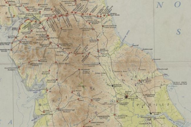
This map image shows the frontier region of Roman Britain. Source: Ordnance Survey
The ‘Vicus’ Settlement at Brougham
Excavations towards the western end of the project have centred on the Roman settlement adjacent to the Roman fort at Brougham / Brocavum, which was likely established between AD 78 to 84 and remained in use until the end of the fourth century. Starting out as a military outpost alongside the road, in the late 2nd and early 3rd century AD an adjacent settlement developed, referred to as a ‘vicus’.
First stripping of the area directly adjacent to the modern day road revealed a variety of features which appear to represent the backyards of plots running along the road. A further area revealed a number of stone built structures and cobbled surfaces and domestic structures have been excavated, including the dry stone well shown in the picture below.
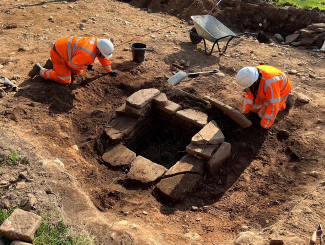
A stone lined well under excavation. Source: Oxford Cotswold Archaeology
DEA 305, one of the detailed excavation areas, had three distinct occupation layers which demonstrate a variety of different uses for this space throughout time. The earliest phase included the appearance of structural features in the form of beam slot buildings.
These were then replaced by stone structures in the middle phase, of which the foundations still remained as well as a variety of cobbled surfaces. The later phase saw the introduction of industry in the area demonstrating a change of purpose and activity.
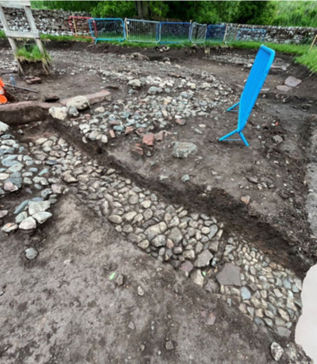
Image shows the different phases of cobbled surfaces under excavation. Source: Oxford Cotswold Archaeology
Artefacts such as pottery are giving further glimpses into the daily lives of those who lived in these communities. The remains of a leather hobnail boot have even been recovered demonstrating the continued military presence in the communities outside the traditional fort.
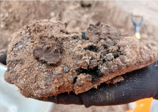
Image shows the remains of a hobnail boot. Source: Oxford Cotswold Archaeology.
The associated cemetery
Previous excavations in the 1960s made it clear that there was a substantial cemetery associated with the fort and settlement at Brougham. The upgrades to the modern A66 have allowed us to take a much closer look at this area.
Archaeologists have uncovered around 340 graves and numerous further funerary features giving an insight into death and burial practices during the Roman period as well as the community that lived in this small fort at the edge of the Roman world.
This cemetery has demonstrated a variety of burial methods, including cist burials, urned cremations and unurned cremations. Many were buried with a variety of grave goods and accessory vessels including jewellery and decorated bone. One stone-capped burial feature produced numerous finds including copper alloy bracelets and a brooch pin as well as glass and carved bone objects. These were found associated with a decorated Samian ware bowl illustrating a hunting scene.
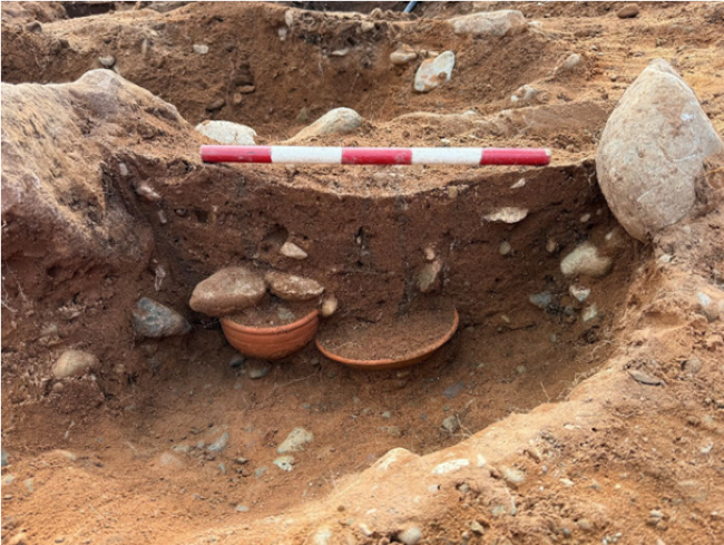
Image shows evidence of cremation burial with accessory vessels. Source: Oxford Cotswold Archaeology.
A particularly exciting find is the pipe clay figurine pictured below. This was found alongside human remains and an intact glass cup in a cist burial and seems to depict a male youth wearing a tunic, cloak and a Phyrgian cap. It has been suggested that this may represent the god Attis, a Phyrgian deity and may point to the multi-culturalism and interconnectedness of the community that lived here. A gold ring found in another burial provides a glimpse into the wealth and status of individuals living here.
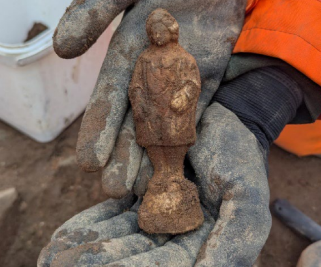
Figurine found in cremation burial. Source: Oxford Cotswold Archaeology.
The Roman Road
Excavations have revealed further detail about the route and composition of the Roman road which follows the route of the modern A66. Excavations towards the eastern end of the project, nearer to Brougham have revealed large stretches of the Roman road surviving running alongside the modern A66.
A well preserved metalled surface was revealed on the projected line of the road, shown in the picture below. A further section of nearly 600m was revealed which included preserved cobbles and a clearly defined embankment (agger).
Image shows a section of the Roman road. Source: Oxford Cotswold Archaeology.
An interconnected region
Artefactual evidence found throughout the excavations along the A66 have demonstrated that this region was not an isolated outpost of empire but connected far and wide with the Roman world.
A large amount of Samian ware pottery has been found throughout the excavation areas. Samian ware is a specific type of fine, glossy Roman pottery made in Gaul, modern day France and the Rhineland, and prized across the Roman Empire for its quality and distinctive red finish.
Samian ware was often seen as a luxury good, and imported from the continent in large amounts. Samian ware can often include a maker’s mark which can allow us not only to identify the workshop a pot was made in, but even the person who made it.
For example, a bowl found within the cemetery of Brougham has provisionally been identified as made by Marinus III, a potter who worked in several East Gaulish factories, including Rheinzabern, between AD 155 and 220.
Further analysis of finds and burial evidence planned in the future will likely uncover further evidence of the connection between Cumbria and the Roman world which the road that follows the A66 facilitated during this period.
This analysis will also hopefully reveal more about the lives of the people who dwelled alongside this Roman thoroughfare and maybe even the origins of the garrisons and their families who made this part of the Roman world home.
Samian ware with maker’s mark of Marinus III. Source: Oxford Cotswold Archaeology.
Protecting and building heritage
As the A66 corridor passes through areas of rich archaeological and environmental significance, including parts of the North Pennines Area of Outstanding Natural Beauty, AtkinsRéalis is working to ensure that heritage assets are identified, recorded, and, where practicable, preserved.
Archaeological investigations along the route have rewritten our understanding of the archaeology of the Eden Valley and are helping to build a deeper understanding of the region’s past, while informing the design and delivery of the upgrade scheme.
Our environmental specialists are also supporting efforts to protect local habitats, reduce carbon emissions, and ensure that the scheme aligns with national sustainability goals.
You can read more about the role of AtkinsRéalis on the Northern Trans-Pennine Upgrade here.
We are proud to be working with our delivery partners on this important project:

Please note that you are now leaving the AtkinsRéalis website (legal name: AtkinsRéalis Group inc.) and entering a website maintained by a third party (the "External Website") and that you do so at your own risk.
AtkinsRéalis has no control over the External Website, any data or other content contained therein or any additional linked websites. The link to the External Website is provided for convenience purposes only. By clicking "Accept" you acknowledge and agree that AtkinsRéalis is not responsible, and does not accept or assume any responsibility or liability whatsoever for the data protection policy, the content, the data or the technical operation of the External Website and/or any linked websites and that AtkinsRéalis is not liable for the terms and conditions (or terms of use) of the External Website. Further, you acknowledge and agree that you assume all risks resulting from entering and/or using the External Website and/or any linked websites.
BY ENTERING THE EXTERNAL WEBSITE, YOU ALSO ACKNOWLEDGE AND AGREE THAT YOU COMPLETELY AND IRREVOCABLY WAIVE ANY AND ALL RIGHTS AND CLAIMS AGAINST ATKINSRÉALIS, AND RELEASE, DISCHARGE, INDEMNIFY AND HOLD HARMLESS ATKINSRÉALIS, ITS OFFICERS, EMPLOYEES, DIRECTORS AND AGENTS FROM ANY AND ALL LIABILITY INCLUDING BUT NOT LIMITED TO LIABILITY FOR LOSS, DAMAGES, EXPENSES AND COSTS ARISING OUT OF OR IN CONNECTION WITH ENTERING AND/OR USING THE EXTERNAL WEBSITE AND/OR ANY LINKED WEBSITES AND ANY DATA AND/OR CONTENT CONTAINED THEREIN.
Such waiver and release specifically includes, without limitation, any and all rights and claims pertaining to reliance on the data or content of the External Website, or claims pertaining to the processing of personal data, including but not limited to any rights under any applicable data protection statute. You also recognize by clicking “Accept” that the terms of this disclaimer are reasonable.
The information provided by Virtua Research cited herein is provided “as is” and “as available” without warranty of any kind. Use of any Virtua Research data is at a user’s own risk and Virtua Research disclaims any liability for use of the Virtua Research data. Although the information is obtained or compiled from reliable sources Virtua Research neither can nor does guarantee or make any representation or warranty, either express or implied, as to the accuracy, validity, sequence, timeliness, completeness or continued availability of any information or data, including third-party content, made available herein. In no event shall Virtua Research be liable for any decision made or action or inaction taken in reliance on any information or data, including third-party content. Virtua Research further explicitly disclaims, to the fullest extent permitted by applicable law, any warranty of any kind, whether express or implied, including warranties of merchantability, fitness for a particular purpose and non-infringement.
The consensus estimate provided by Virtua Research is based on estimates, forecasts and predictions made by third party financial analysts, as described above. It is not prepared based on information provided by AtkinsRéalis and can only be seen as a consensus view on AtkinsRéalis' possible future results from an outside perspective. AtkinsRéalis has not provided input on these forecasts, except by referring to past publicly disclosed information. AtkinsRéalis does not accept any responsibility for the quality or accuracy of any individual or average of forecasts or estimates. This web page contains forward-looking statements based on current assumptions and forecasts made by third parties. Various known and unknown risks, uncertainties and other factors could lead to material differences between AtkinsRéalis' actual future results, financial situation, development or performance, and the estimates given here.
-
Markets
-
Services

Simon Peevers
Senior Advisor External Communications, Bristol, United Kingdom contact form+44 1454 667 587
Downloads
Trade releases